PARCEL VIEWER
California land parcel research made easy.
WILDFIRE VIEWER
The leading web maps for tracking wildfires.
CUSTOM MAPS
Custom web map solutions to meet your needs.
Why MapPort®?
Geospatial analysis is fundamental to all industries having to manage information that has location importance. Yet some sectors remain underserved. The current marketplace offers basic one-size-fits–all subscription maps, where users are expected to make their own maps, or sophisticated map software requiring an in-house GIS specialist. MapPort fills the gap. Using our platform, the operator can create custom on-line maps, tailored to the unique needs of the client, affordably, effectively, and remotely. Our maps are so intuitive, user know-how is immediate.
The MapPort advantage
MapPort® is an online geospatial software platform on which unique interactive, maps are quickly built, deployed, and maintained remotely for the use of any economic sector, private or public. It is open source based, independent of the expensive, limiting software of the single GIS industry giant.
- MapPort leverages global standards-based open-source geospatial code stack, the same as powers services such as AWS and Uber.
- Google Angular gives our code structure state of the art fluidity of extension and integration with emerging standards-based strata software.
- Secure US based Liquid Web cloud servers store our platform, proprietary data layers, and client-owned datasets.
- Recurly, our e-commerce front end allows the option of broad distribution via subscription.
- Seamless compatibility with all common GIS, CAD, and database file formats.
- Live Share and Collaborator Seats provide data and platform sharing
- MapPort’s rich data library includes Data Tree First American Title parcel property details, primary sources such as NOAA, NASA, California DWR, . . . continuously maintained, and served fresh across all client maps.

Key Features, Capabilities and Components
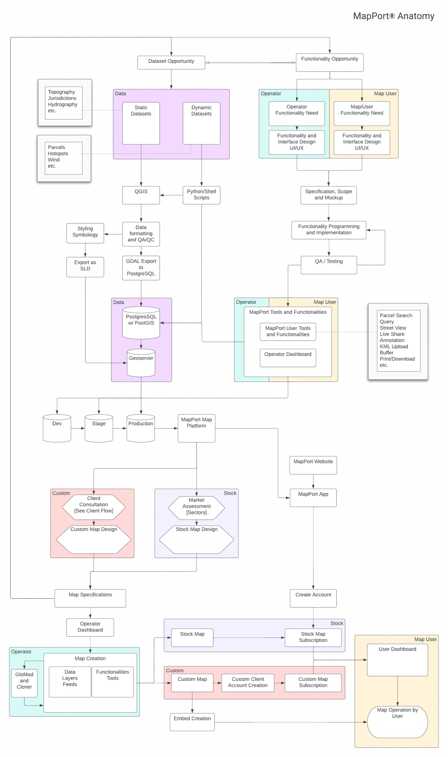
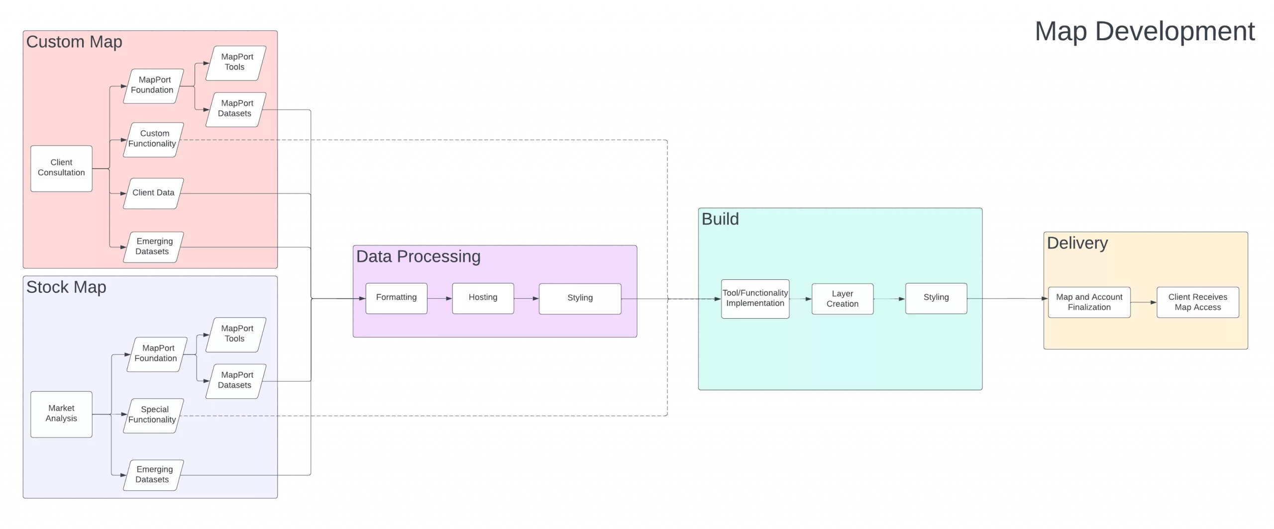
MapPort allows rapid construction and deployment of tailored map experiences drawing on a rich stock of built-in data and functionalities, with the flexibility to seamlessly incorporate customized content configured by a GIS technician. A powerful feature of the platform is the unique data model which defines and serves maps and layers as classes, not singular objects. MapPort houses multiple consumer map products without replicating core data sources or components, avoiding repetitive and costly individual map, layer, and tool configuration, without relying on a cookie-cutter approach. This capability underlies a highly efficient ecommerce engine that can bootstrap all data, functionality, and content on the platform. At the same time, MapPort components can be fully configured, customized, and extended to serve client needs in specially designed Custom Maps, including enterprise grade systems. A robust account management feature set gives organizations intuitive internal control and makes customer support simple and flexible.
The versatility of the platform owes to its powerful, reliable and evolvable architecture, leveraging industry-leading open-source technologies. Combining high value datasets and high impact user-friendly features, MapPort is a full-service web map solution that unlocks geospatial intelligence for market sectors underserved by legacy solutions.
MapPort utilizes a strict front end/back-end setup, powered by Angular and Django respectively, to cleanly separate data and map operations from the user experience which can vary widely based on configurations stored on the back end. App logic and state is stored in a Postgres database managed through Django.
The map and data stack extends this with PostGIS in a separate geospatial Postgres database instance, visualized via open-source components GeoServer and OpenLayers. Elastic provides out-of-the-box smart search capability for parcels and other data layers.

Endless possibilities
MapPort supports a range of map-based user activities: environmental conditions investigation, management of distributed resources, site analysis, use viability assessment, risk assessment, disaster preparedness engineering, infill and ADU opportunity identification and development, educational facilities administration, land assembly, municipal infrastructure maintenance and so on. Dedicated maps for industry sectors or organizations are easily spun up and access sold via subscription or otherwise. Contact us for more information about investment and acquisition options at wmsgroup@enplan.com or (530) 402-4783.
© ENPLAN 2024 All rights reserved.
MapPort® is a web map services platform created by ENPLAN.
Privacy Policy Terms of Service
support@enplan.com