About our property data
 We strive to provide the most complete and up-to-date property data feasible in a form digestible for our users. As some of our multi-county users may have noticed, the property data available from each county can vary. Below is a list of the parcel data or attributes included with most county maps:
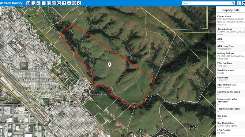
- Owner Name
- Situs Address
- Assessor Parcel Number (APN)
- Mailing Address
- Last Sale Date
- Parcel Size
- Land Value
- Improvement Value
- Total Value
- Assessor Use Codes and Use Description
- Zoning
- Land Conservation Act (Williamson Act) status
Select parcels in the county preview PARCEL VIEWER map to see available data. You can also visit the glossary on our support page for detailed descriptions of each of the attributes we provide.
You may be aware that some county assessors compile other data, such as the applicable school district, general plan designations, building square footage, year built, and more.
Upon obtaining assessor data from a county, we first process it to ensure that property data integrity is optimized. We then incorporate it in our map platform along with current parcel boundaries, or parcel “geometry” as supplied by each county. The PARCEL VIEWER team does not actually draw the property lines that you see in our maps.
We update PARCEL VIEWER geometry and property data quarterly or consistent with county publishing schedules, if less frequent. County updates can be daily, monthly, quarterly, or annually. It is important to note that some data, such as land and improvement values, are only updated annually by all counties. View our update schedule here.
Perhaps you find viewing parcel lines over aerial imagery the most beneficial, or appreciate saving a trip to the assessor to obtain key property data. Please let us know of your favorite PARCEL VIEWER data or benefit, or if you wish to see additional assessor data for a particular county.