Ag parcel line accuracy and easements
 PV CLIENT: We are researching the property lines on our agricultural land because of an easement issue. I know we should have our property professionally surveyed but I am wondering how accurate are the maps I bring up on Parcel Viewer? What information is being used to create the lines that I see as the boundaries for my parcel? Thank you, Deb.
RESPONSE: Good question. We only display parcel layers as compiled by the respective counties in our maps. Accuracy varies widely depending mainly on the resources available to the county at the time the parcel boundary layer was compiled. A variety of reference information is used in that process, including assessor parcel maps, subdivision record maps, transportation rights-of-way maps, the Public Land Survey System, and so on. We do not attempt to modify county parcel layers where inaccuracies are apparent. That process is best handled at the county level where land division record maps are stored and maintained.
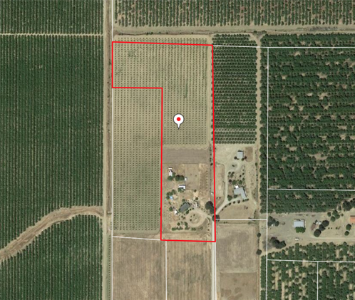
In your case, screenshot attached, the boundary portrayed for your property is certainly inaccurate. A giveaway is that the displayed boundaries are not rectilinear as are the fields. In most cases, the Public Land Survey System (PLSS) was used as a convenient framework for defining large agricultural parcels, and the PLSS is very rectilinear for the most part. The parcel boundary most likely follows features like roads shared between fields, shared irrigation ditches, and so on. Of course the accuracy of their placement on the ground is also dependent on the resources available at the time the fields were laid out.
To address the inaccuracy, to start, I suggest that you check if there is a record of survey on file for your parcel with the county clerk. While at it, you might get lucky and find some corner monuments on the ground. Otherwise, you should have a meets and bounds description associated with the deed available. The record map and description could be used by a surveyor to trace out boundaries on the ground and defined in digital space using real world coordinates. The digital description should be given to the county agency responsible for maintaining the parcel base layer along with a formal written request that they correct their base with respect to your parcel.
As to easements, you should check any record of survey map for or abutting your parcel as well as meets and bounds descriptions available. You should also check the assessor parcel map encompassing your parcel that is created by and on file with the county assessor. While these maps are not usually survey-grade, they often show easements in relation to parcel lines. Such depictions should have been derived from authoritative sources. They are maintained typically in PDF format, often downloadable from the county website, and printable on standard 11″x17″ paper (in California). Otherwise you should be able to get a print from the office of the assessor directly.