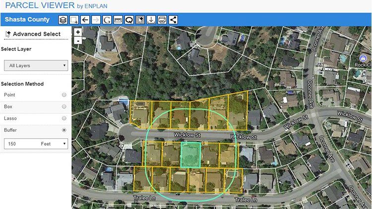
ENPLAN will introduce an additional Parcel Viewer functionality available as an ad-on for users needing to select map features within a set distance of an object feature. Example: municipalities commonly notify property owners within a certain distance surrounding parcels for which a use permit or entitlement change has been requested. Selection of this sort is called “buffering” in the geospatial world and the new OUTREACH functionality automates this process fully. Many clients other than municipalities will also find this functionality useful.
The buffer notification distance from the object parcel is first set by the user. The buffer line appears on the map encompassing and intersecting parcels selected, thereby allowing visual corroboration by the user that the selection is correct. PDF lists, CSV files, and mailing labels can be created quickly for the parcels meeting the buffer criteria. Municipalities commonly try to notify 300-500 feet out from the edge of subject parcels and this can be accomplished very precisely by OUTREACH.
Users can also find and search by owner, address, and assessor parcel number as needed and also see property values, use codes, acreage and other assessor data by simply clicking on the parcels.
The more subtle features of OUTREACH will also be appreciated by many. Here are some:
- A list record of parcel owners and occupants notified along with other property data can be created for staff reports and inclusion in application files as a simple by-product of the data extraction process.
- A printable PDF map can be created and labeled, showing the subject parcel, buffer line and surrounding parcels within the buffer distance set. The map can be printed for inclusion in notice mail-outs, reports, brochures and/or application files.
- Option to purge redundant property owner records selected. Owners can often own multiple parcels within a desired notification buffer.
- Option to include on the mailing label the APNs of the parcels whose owners are being notified.
- Option to include occupants if different from the owner of record. Here the situs address is used and the word Occupant is inserted in place of the owner name.
- Individual parcels beyond or within the buffer set by the user can be added to or deleted with simple mouse-clicks on the parcels.
- Multiple parcels can be selected and added using the Lasso tool. This tool allows batches of parcels to be selected, and thereby their property attribute data extracted, in whatever configuration is defined by the user.
OUTREACH will become available spring 2018.